
Waterways of Wyoming
By: Katelyn Parker
Wyoming is home to a massive network of rivers, lakes, and streams that all support the unique ecosystem in their respective area. Over time the rivers have carved the Wyoming landscape, creating geographic marvels such as incredible canyons and river valleys. Most waterways in the contiguous United States eventually make their way to the Atlantic or Pacific oceans via the main water arteries such as the Columbia, Colorado, and Mississippi Rivers. The Continental Divide dictates which course our waters will take. Water on the east side of the divide will make its way to the Gulf of Mexico and water on the west will eventually flow into the Pacific. The Continental Divide cuts through Wyoming, dictating the direction and end location of the water that flows through the state.

Wyoming River Basins
Wyoming’s waterways are separated into six river basins. The river basins are determined by surveying the fall and flow of waters and borders are declared when it has been established that all the water in a region flows within those borders until eventually carried to a tributary of one of the main water arteries. Within these river basins are several rivers, streams, natural lakes, and reservoirs; all of which play a key role in the landscape and ecosystem. The six river basins and their major bodies of water are:

The Snake/Salt River Basin
The Snake/Salt River basin is located on the central/northeastern border of the state. Within the Snake/Salt River Basin flows the Snake and Salt rivers, the Snake River being the largest tributary of the Columbia River which empties into the Pacific Ocean off the coast of Washington. The Snake is one of Wyoming’s more pristine and wild rivers, due to the protection of the national parks through which it flows. The Snake River’s headwaters are in Yellowstone National Park, and it flows south into Grand Teton National Park until it makes its way through Idaho, Oregon and then into Washington. The Snake River is the inflow for Jackson Lake, nestled under the Teton Mountains in Grand Teton National Park and is one of the most photographed and visited lakes in the contiguous United States. The Snake is popular among anglers, kayakers, river rafters and several species of wildlife.


Bear Basin
The Bear River Basin is the smallest river basin in the state, and it is situated on the southwestern border. The main river within the basin is the Bear River which is the longest river in North America that doesn’t ever reach the sea. The Bear River starts in Utah and flows north through the southwest corner of Wyoming, winding its way north along the Utah/Wyoming border until it flows into Idaho before looping back into Utah where it drains into the Great Salt Lake. The Bear River Basin provides water for irrigation for parts of both Lincoln and Uinta Counties and is integral in the sustainability of agriculture in the area. Bear River is the inflow for Pixley dam in Lincoln County.
The Wind/Bighorn River Basin
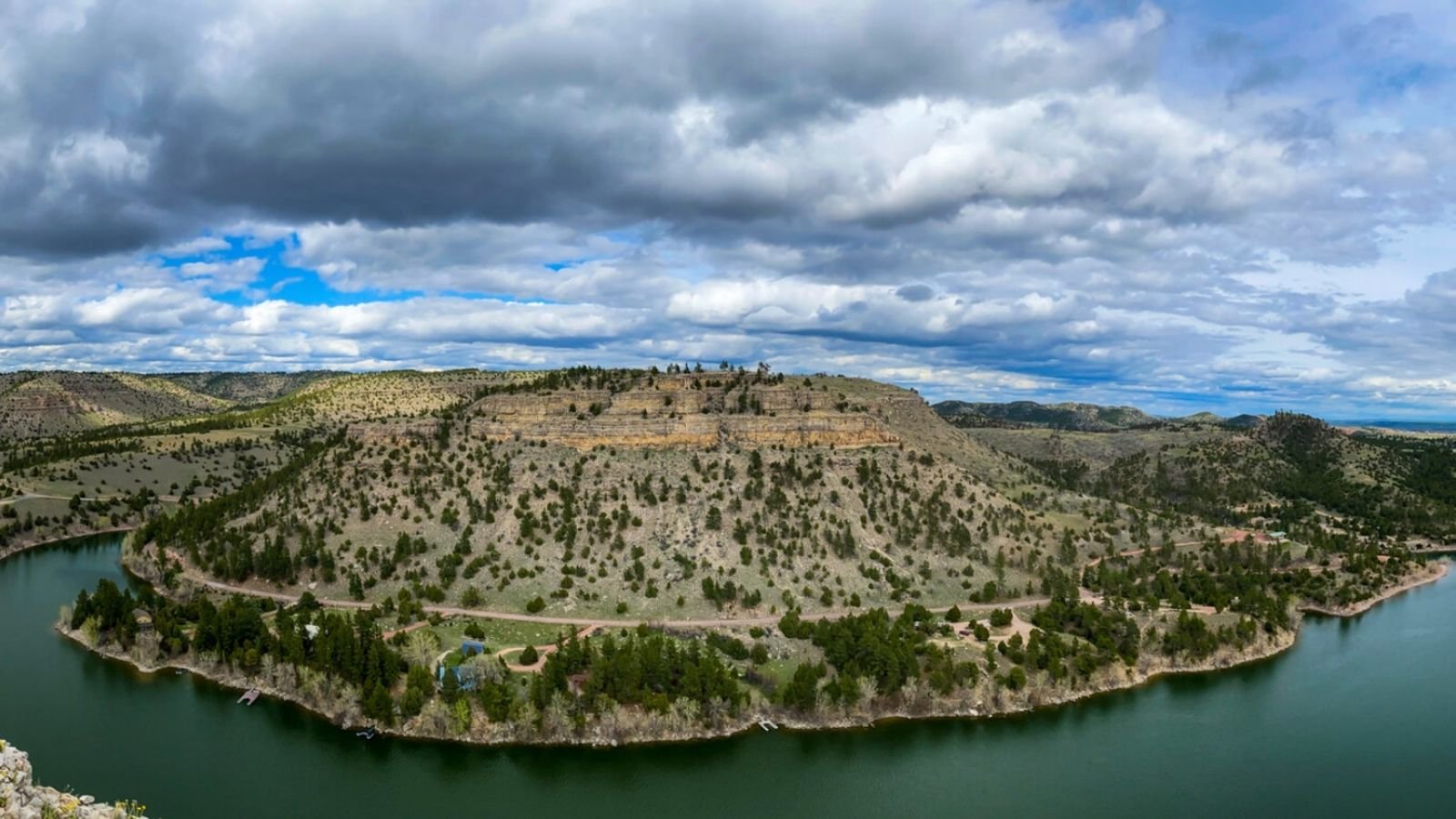
The Wind/Bighorn River Basin is a large river basin with several rivers and their tributaries running through it. Some of the main rivers in this basin are the Shoshone, Greybull, Wind and Bighorn Rivers. The Wind River flows southeast through Riverton and the Wind River Basin before feeding Boysen Reservoir at the south end of the Wind River Canyon. After the canyon, the Wind becomes the Bighorn River at the wedding of the rivers. As the Bighorn flows north along the Bighorn Mountains it is fed by the Greybull and Shoshone Rivers, stewarding the converging waters north through the Bighorn Canyon and into Montana where it meets the Yellowstone River. The Yellowstone River is a tributary of the Missouri River which eventually carries the water to the Mississippi which flows into the Gulf of Mexico.
The rivers that flow through the Wind/Bighorn River Basin are responsible for geographic phenomenas such as the Wind River Canyon, the Bighorn Canyon and Yellowstone Canyon. The Bighorn, Wind, and Shoshone Rivers are all inflows for their respective reservoirs. The Bighorn River feeds the Bighorn Reservoir which sits below the Yellowtail Dam and winds through Bighorn Canyon Recreation Area. The Wind River is the inflow for Boysen Reservoir and the Shoshone River is the inflow for the Buffalo Bill Reservoir. The Wind/Bighorn River Basin also encompasses parts of Yellowstone National Park which adds Yellowstone Lake and Yellowstone River to the list of amazing water features in this river basin. The Wind/Bighorn River Basin is popular amongst outdoor enthusiasts of all types and is a popular tourist destination.

The Greater Green Basin
The Greater Green River Basin is situated in southwestern Wyoming and encompasses Rock Springs, Green River, and several other communities. This river basin is home to the Green, New Fork, Big Sandy, and Blacks Fork Rivers. The Green River is one of the longest rivers in the state and feeds two reservoirs in the Greater Green River Basin; Fontenelle and Flaming Gorge. Green River starts in the Wind River Mountains and travels south through Wyoming, collecting the waters from the New Fork, Big Sandy, and Blacks Fork Rivers. From Wyoming Green River travels into Utah and winds its way to Colorado until it sweeps back into Utah where it meets the Colorado River which meets the Pacific Ocean in southern California.
Flaming Gorge Reservoir is the largest in Wyoming and is a popular location for outdoor enthusiasts year-round. Flaming Gorge Recreation Area attracts hikers, backpackers, boaters, windsurfers, water sports enthusiasts and fisherman in the summer months, making it one of southern Wyoming’s most attended recreation destinations. In the winter, ice fisherman flock to the ice, participating in weekend winter fun or to participate in one of the popular ice derbies. Some of the fish that can be caught in Flaming Gorge include trout, Kokanee salmon and Burbot.

The Northeast River Basin
The Northeast River Basin is in the northeast corner of Wyoming and is home to the Powder, Little Missouri, Belle Fourche, Cheyenne and Niobrara Rivers. The Powder River begins in northeastern Wyoming travels north into Montana where it meets the Yellowstone River which carries the waters to the Missouri and eventually to the Mississippi and the Gulf of Mexico. The Little Missouri is also a tributary of the Missouri River and gets its start in northeastern Wyoming and cuts through the southeast corner of Montana before flowing through South Dakota. The Belle Fourche River starts in the Northeast River Basin and flows northeast through Wyoming where it flows into the Keyhole Reservoir. The tailwaters of the Belle Fourche travel into South Dakota where it meets the Cheyenne River which also begins in the Northeast River Basin and a tributary of the Missouri River. The Niobrara River rises in the southeast corner of the Northeast River basin and has a short segment in Wyoming before flowing into Nebraska where it meets the Missouri River. The waters that flow through the Northeast River Basin eventually flow through the Mississippi River Delta to the Gulf of Mexico.

The Platte River Basin
The Platte River Basin encompasses the southeast part of the state and benefits communities such as Laramie, Cheyenne, and Rawlins. The main river in the Platte River Basin is the North Platte River which rises in Colorado and horseshoes through the Platte River Basin before it flows into Nebraska, converging with the South Platte River to form the Platte and continue its journey through Nebraska to the Missouri River. Some of the main tributaries for the North Platte River include the Laramie, Medicine Bow, and Sweetwater Rivers. Along its journey through Wyoming, the North Platte River is the inflow to several reservoirs including Seminoe, Alcova, Pathfinder, Guernsey, and Glendo. The North Platte River and all its tributaries and reservoirs provide the communities within the Platte River Basin with resources and recreation opportunities.
Even though Wyoming is considered a high desert, the waters that flow through the state leave little to be desired. Outdoor enthusiast from around the world travel to Wyoming to enjoy world class fishing, boating, site seeing and more. Many of the waters that sustain communities and ecosystems outside of Wyoming get their start in the high plains or the rocky mountain ranges right here in the Cowboy State. Wyoming is unique for several reasons and the flow of our waters and the abundance of life it creates is just one of them.